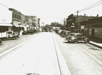
I had a great time looking at those old photographs and mentally comparing them to how Central Avenue looks today. I thought you might also enjoy a look at Central Avenue "then and now".
Marty had 12 prints that were not in frames and he loaned them to me for the afternoon. I had the prints scanned into digital pictures and I've posted them here.
The photos are arranged from east to west. The caption for each photo gives the rough description of the vantage point and what the photo shows.
Last Friday afternoon, I went out and took "now" photos... trying to get as close to the original vantage point as I could (without getting run over!). I cropped my new photos so that they showed a view that is as close to the old photo as possible.
I hope you enjoy the look back as much as I did. The photos show up fairly small in the blog, but the originals that I uploaded are really big, so if you click on one picture, you'll be able to view them all in a much larger size.
The first photo is dated August 11, 1945, so I assume that all of the photos were taken sometime in the mid 1940s.
I'm sure you'll all see different details, but here are a few things that stood out to me:
- There was diagonal parking along Central Avenue in all of the old photos, BUT there was no "center turn lane". Looks like we had to trade one for the other.
- There are lots and lots of overhead wires in the old photos.
- There are streetcar (trolley) tracks and/or streetcars (trolleys) in every photo. So... we used to have "light rail", then we tore it out and now were thinking about putting it back. :-)
- There were very few gaps between buildings in the old photos. Central Avenue "today" has what I call "hillbilly teeth" (i.e., one building... a lot of empty space... another building... etc.) compared to Central Avenue "then".
- There are tons of people and cars in almost every photo.
- The old streetlights looked cool.
Enjoy!
= = = = = = = = = = = = = = =
 |
| Looking east towards 7th Street while standing at Simpson Avenue. |
 |
| Not nearly as many buildings in this view. |
= = = = = = = = = = = = = = =
 |
| Still looking east towards 7th Street, but a little further around the bend. |
 |
| Almost none of the buildings on the north (left) side of the street still exist. |
= = = = = = = = = = = = = = =
 |
| Looking west toward 10th Street from about Ferree Street. |
 |
| All of the old buildings east of 10th (close to the camera) are gone. |
= = = = = = = = = = = = = = =
 |
| Looking southeast while standing at the corner of 10th and Central. |
 |
| There used to be a building on the triangle that is now Lally Park (tall evergreen)!! |
= = = = = = = = = = = = = = =
 |
| Looking east toward 10th and Central from about Baltimore St. |
 |
| Look at all the old buildings that are "missing" on the left side of the street. (I still remember what it smelled like the night Drew Hardware burned.) |
= = = = = = = = = = = = = = =
 |
| Looking east from between 16th and 17th Streets. |
 |
| A pretty comparable view. |
= = = = = = = = = = = = = = =
 |
| Looking west to the intersection of Central Avenue, 18th Street and Park Drive. |
 |
| Wow! All the buildings on the right side of Central are now gone. Also gone is the Standard Service station and the house on what is now Trolley Park (middle of photo). |
= = = = = = = = = = = = = =
 |
| On the other side of the intersection... Looking east at the intersection of Central Avenue, 18th Street and Park Drive. |
 |
| This photo is from street level since there's no wall behind the Standard Service station to climb on. |
= = = = = = = = = = = = = = =
 |
| It's amazing to me that we took away the gas station, house and all the dirt in the little triangle that is now Trolley Park. |
= = = = = = = = = = = = = = =
 |
| Looking southwest along Park Drive from 21st Street. |
= = = = = = = = = = = = = = =
 |
| Looking "back" northeast along Park Drive from about 22nd Street. |
 |
| The road is in much better shape without the trolley tracks. |
= = = = = = = = = = = = = = =
 |
| Looking west along Park Drive between 22nd and 23rd Streets. |
= = = = = = = = = = = = = = =
Click a link below to send me a message if you have any thoughts or observations.
If anyone has any old / historical photos of Minnesota Avenue or Kansas Avenue, please drop me a note. I'd love to scan those photos to digital pictures and do a "then and now" look at those avenues as well.
Have a great week!
bmckiernan@wycokck.org
- or -
Suggestion Box


